2009 Edition Part 3 Figure 3B-4. Method of Locating and Determining the Limits of No-Passing Zones at Curves
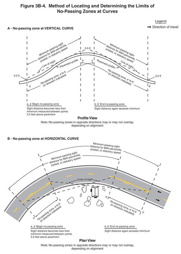
Figure 3B-4. Method of Locating and Determining the Limits of No-Passing Zones at Curves
This figure illustrates two methods of locating and determining the limits of no-passing zones at curves.
A legend shows a black arrow indicating the direction of travel in the lanes.
Notes for both sections of the figure state that "No-passing zones in opposite directions may or may not overlap, depending on alignment."
The top half of the figure is labeled "A - No-passing zone at vertical curve." It is also labeled the profile view of a vertical curve.
- A horizontal cross-section of a vertically curving roadway is shown, with the left and right halves labeled "Pavement profile." A note states "a, a' Begin no-passing zone. Sight distance becomes less than minimum measured between points 3.5 feet above the pavement." Another note states "b, b' End no-passing zone. Sight distance again exceeds minimum."
- At the far left, a vertical broken black line is labeled "a." Farther right, just in advance of the crest of the curve, another vertical broken black line is labeled "b'." To the right of the crest of the curve, a vertical broken black line is labeled "b," and at the far right, another is labeled "a'." On the left, a leader arrow points to line "a" and another to line "b" from the label "No-passing zone, a to b (in direction indicated)." On the right, a leader arrow points to line "a' " and another to line "b' " from the label "No-passing zone, a' to b' (in direction indicated)."
- At points on each of the four vertical black lines, a point above the surface of the pavement is labeled "3.5 ft." A broken black line connecting these points on lines "a" and "b' " is labeled "Line of sight," and another connecting these points on lines "b" and "a' " is also labeled "Line of sight."
- On the left, a leader arrow points to line "a" and another to line "b' " from the label "Minimum passing sight distance for 85th percentile, posted, or statutory speed." On the right, a leader arrow points to line "b" and another to line "a' " from the label "Minimum passing sight distance for 85th percentile, posted, or statutory speed."
The bottom half of the figure is labeled "B - No-passing zone at horizontal curve." It is also labeled the plan view of a horizontal curve.
- A horizontal two-lane roadway is shown with a curve in the middle portion. Symbols for a house and trees are shown south of (on the inside of) the curve. A black arrow is shown pointing east in the eastbound lane, and another is shown pointing west in the westbound lane. The lanes are separated by a broken yellow line. A note states "a, a' Begin no-passing zone. Sight distance becomes less than minimum measured between points 3.5 feet above the pavement." Another note states "b, b' End no-passing zone. Sight distance again exceeds minimum."
- At the left end of the roadway, a broken black line is shown across the width of the roadway and is labeled "a." To the right, another broken black line is shown across the roadway and is labeled "b." The dimension from "a" to "b" is labeled "No-passing zone, a to b (in direction indicated)." Between these two points, a solid yellow line is shown to the right of the broken yellow line between the lanes.
- At the right end of the roadway, a broken black line is shown across the width of the roadway and is labeled "b'." Farther to the right, another broken black line is shown across the roadway and is labeled "a'." The dimension from "a' " to "b' " is labeled "No-passing zone, a' to b' (in direction indicated)." Between these points, a solid yellow line is shown to the right of the broken yellow line between the lanes.
- Two broken black lines denote distances labeled "Lines of sight." One connects the point where the broken black line labeled "a" intersects the center of the roadway to the point where the line labeled "b' " intersects the center of the roadway, and the other connects the point where the line labeled "b" intersects the center of the roadway to the point where the line labeled "a' " intersects the center of the roadway.
On the left, the distance along the outer roadway curve from line "a" to line "b' " is labeled "Minimum passing sight distance for 85th percentile, posted, or statutory speed." On the right, the distance along the roadway curve from line "a' " to line "b" is labeled "Minimum passing sight distance for 85th percentile, posted, or statutory speed."