2009 Edition Part 2 Figure 2E-34. Examples of Guide Signs for a Freeway-to-Freeway Interchange (Sheet 1 of 2)
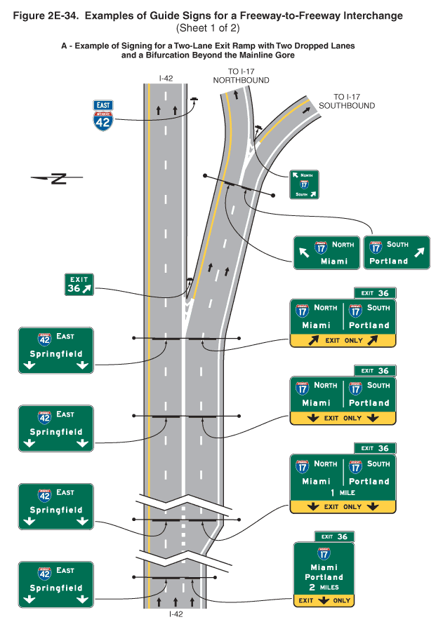
Figure 2E-34. Examples of Guide Signs for a Freeway-to-Freeway Interchange (Sheet 1 of 2)
This figure shows 30 guide signs for a freeway-to-freeway interchange on two sheets.
Sheet 1 shows 13 signs on a figure labeled "A - Example of Signing for a Two-Lane Exit Ramp with a Two Dropped Lanes and a Bifurcation Beyond the Mainline Gore."
The figure shows segments of one direction of a vertical highway depicted with three lanes, expanding to four lanes, with the travel direction from the bottom to the top of the figure. At the bottom of the figure, the three lanes are separated from each other by broken white lines. The broken white line between the two center and right lanes then is shown changing to a dotted wide white line. Farther north an additional (fourth) lane is added along the right side of the highway, separated from the adjacent lane to its left by a broken white line. Farther north, the dotted wide white line between the two leftmost and the two rightmost lanes is shown changing to a solid white line. Farther north, the two leftmost lanes are shown continuing straight, to the left of a theoretical gore shown with white chevron markings, and are shown separated by broken white lines. The two rightmost lanes are shown curving to the right, to the right of the theoretical gore. Near the top of the figure, these two lanes are shown splitting at another theoretical gore shown with white chevron markings. The left lane is shown going to the left of the gore and is labeled "To I-17 Northbound," and the right lane is shown going to the right of the gore and is labeled "To I-17 Southbound."
A series of horizontal rectangular green signs with white legends and borders are shown along the highway from the bottom to the top of the figure. At the top left of the figure, a black capital letter "N" is shown superimposed on a left-pointing horizontal black arrow, denoting the compass direction.
Thirteen signs or sign assemblies are shown on the vertical highway:
- At the bottom of the figure, the first and second signs are shown in a horizontal array over the highway:
- The first sign, on the left, is shown located above the two leftmost lanes. It is shown with the shield for Interstate 42 to the left of the word "EAST" on the top line. Below it, the word "Springfield" is shown on the middle line above two vertical white downward-pointing arrows with short shafts on the bottom line.
- The second sign, on the right, is shown located above the right lane. It is shown with the shield for Interstate 17 on the top line above the word "Miami" on the second line, the word "Portland" on the third line, and the words "2 MILES" on the bottom line. Below these words, a horizontal rectangular yellow panel with a black border and legend is shown with the word "EXIT" to the left of a short vertical downward-pointing arrow to the left of the word "ONLY." A smaller horizontal rectangular green plaque is shown above the top right side of the sign. It shows the words "EXIT 36."
- The third and fourth signs are shown in a horizontal array over the highway at the start of the full width of the four-lane segment of the vertical highway:
- The third sign, on the left, is shown located above the two leftmost lanes. It is shown as identical to the first sign.
- The fourth sign, on the right, is shown located above the two rightmost lanes. It is shown with the shield for Interstate 17 to the left of the word "NORTH" on the top line above the word "Miami" to the left of a vertical white line that divides the top half of the sign into two sections. To the right of the dividing line, the shield for Interstate 17 is shown to the left of the word "SOUTH" and above the word "Portland." The words "1 MILE" are centered below the vertical dividing line. Below these words, a horizontal rectangular yellow panel with a black border and legend is shown with a short vertical downward-pointing arrow to the left of the words "EXIT ONLY" to the left of another short vertical downward-pointing arrow.
- The fifth and sixth signs are shown in a horizontal array over the highway beyond the point where the dotted white line between the two left and two right lanes is shown changing to a solid white line:
- The fifth sign, on the left, is shown located above the two leftmost lanes. It is shown as identical to the first and third signs.
- The sixth sign, on the right, is shown located above the two rightmost lanes. It is shown as identical to the fourth sign except that the words "1 MILE" have been removed.
- The seventh and eighth signs are shown in a horizontal array over the highway at the theoretical gore where the two rightmost lanes split to the right:
- The seventh sign, on the left, is shown located above the two leftmost lanes. It is shown as identical to the first, third, and fifth signs.
- The eighth sign, on the right, is shown located above the two rightmost lanes. It is shown as identical to the sixth sign except that two diagonal arrows pointing up and to the right are shown instead of two downward-pointing vertical arrows.
- The ninth sign is shown in the gore between the two lanes that continue straight ahead and the two lanes that angle off to the right. It is shown as a small sign with the word "EXIT" above the numeral "36" to the left of a diagonal arrow pointing up and to the right.
- At the top of the figure, the tenth sign is shown to the right of the lanes that continue straight ahead. It is shown as a red and blue Interstate route shield on which the white numeral "42" is shown. Above it, a plaque is shown with the word "EAST" in white letters and a white border on a blue background.
- The 11th and 12th signs are shown are shown in a horizontal array over the two lanes that angled to the right. They are shown at the theoretical gore between the lane that splits to the left and the lane that splits to the right:
- The 11th sign, shown over the left lane, is shown with the shield for Interstate 17 to the left of the word "NORTH" on the top line. Below it, a diagonal arrow pointing up and to the left is shown to the left of the word "Miami."
- The 12th sign, shown over the right lane, is shown with the shield for Interstate 17 to the left of the word "SOUTH" on the top line. Below it, the word "Portland" is shown to the left of a diagonal arrow pointing up and to the right.
- The 13th sign is shown in the gore between the lane that splits to the left and the lane that splits to the right. It is shown as a smaller sign with the word "NORTH" to the right of a diagonal arrow that points up and to the left on the top line, the Interstate 17 shield on the center line, and the word "SOUTH" to the left of a diagonal arrow pointing up and to the right on the bottom line.
Continue to: Sheet 2