2009 Edition Part 2 Figure 2D-19. Example of a Community Wayfinding Guide Sign System Showing Direction from a Freeway or Expressway
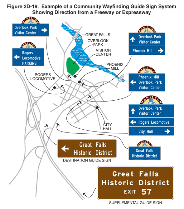
Figure 2D-19. Example of a Community Wayfinding Guide Sign System Showing Direction from a Freeway or Expressway
This figure illustrates a community wayfinding guide sign system showing direction from a freeway or expressway.
The figure shows an overhead view of community map, with a freeway running northwest to southeast to the left of a community of cross streets, with a recreational area to the right. Black squares throughout the community are labeled "Rogers Locomotive," "Phoenix Mill," "City Hall," and "Visitor Center." To the left of the black square labeled "Visitor Center," there is a green area labeled "Overlook Park." Northeast of the green area labeled "Overlook Park," there is a blue area representing a river with a symbol for a bridge shown crossing it and the label "Great Falls."
Black inverted "Ts" denote signs. A series of guide signs are shown along the freeway and the community streets.
At the bottom of the figure, a horizontal rectangular brown sign with a white border and legend is shown to the right of the freeway facing the direction of travel approaching the community. The sign is labeled "Supplemental Guide Sign." The words "Great Falls" are shown in white on the top line, the words "Historic District" are shown in white on the middle line, and the words "EXIT 57" are shown in white on the bottom line.
Closer to the community, another guide sign is shown to the left of the exit ramp from the freeway facing the direction of travel into the community. It is shown as a horizontal rectangular brown sign with a white border and legend. The sign is labeled "Destination Guide Sign." A left-pointing horizontal while arrow is shown to the left of the words "Great Falls Historic District" in white on two lines.
Just beyond this sign, a sign is shown to the right of the roadway entering the community. It is shown as a horizontal rectangular blue sign with a white border and legend. The words "Great Falls Historic District" are shown in white on two lines. A semicircular sign showing the word "HAMILTON" in white on a brown background above a symbol for a waterfall is shown centered on the top of the guide sign.
Beyond this sign and in advance of the cross street showing the location of City Hall, a large guide sign is shown to the right of the main roadway. It is shown as a horizontal rectangular blue sign with a white border and legend. An upward-pointing vertical white arrow is shown to the left of the words "Overlook Park Visitor Center" in white on two lines and above a horizontal white line that extends across the width of the sign. Below this line, a left-pointing horizontal white arrow is shown to the left of the words "Rogers Locomotive" in white on one line and above a horizontal white line that extends across the width of the sign. Below this line, the words "City Hall" are shown to the left of a right-pointing horizontal white arrow on one line. A semicircular sign showing the word "HAMILTON" in white on a brown background above a symbol for a waterfall is shown centered on the top of the guide sign.
To the left of the main roadway on the cross street showing the location of City Hall, a guide sign is shown to the right of the roadway in advance of the location of Rogers Locomotive. The sign is shown as a horizontal rectangular blue sign with a white border and legend. A left-pointing horizontal white arrow is shown to the left of the words "Rogers Locomotive PARKING" in white on three lines. A semicircular sign showing the word "HAMILTON" in white on a brown background above a symbol for a waterfall is shown centered on the top of the guide sign.
On the main roadway and just beyond the cross street showing the location of City Hall, a guide sign is shown to the right of the roadway. It is shown as a horizontal rectangular blue sign with a white border and legend. A left-pointing horizontal white arrow is shown to the left of the words "Phoenix Mill" in white on the top line, "Overlook Park" in white on the middle line, and "Visitor Center" in white on the bottom line. A semicircular sign showing the word "HAMILTON" in white on a brown background above a symbol for a waterfall is shown centered on the top of the guide sign.
On the cross street just beyond this sign and to the left of the main roadway, a guide sign is shown to the right of the roadway in advance of the location of Phoenix Mill. It is shown as a horizontal rectangular blue sign with a white border and legend. An upward-pointing vertical white arrow is shown to the left of the words "Overlook Park Visitor Center" in white on two lines and above a horizontal white line that extends across the width of the sign. Below this line, the words "Phoenix Mill" are shown to the left of a right-pointing horizontal white arrow. A semicircular sign showing the word "HAMILTON" in white on a brown background above a symbol for a waterfall is shown centered on the top of the guide sign.
Beyond this sign on the cross street, another guide sign is shown to the right of the roadway and to the left of the location for Overlook Park. The words "Overlook Park" are shown in white on the top line, and the words "Visitor Center" are shown in white on the bottom line. A right-pointing horizontal white arrow is shown to the right of the text. A semicircular sign showing the word "HAMILTON" in white on a brown background above a symbol for a waterfall is shown centered on the top of the guide sign.